The Mastering Genealogical Documentation Study Group is back! Registration is now open!
Mastering Genealogical Documentation, a Seven-Week Beginning Principles Course, lead by Cyndi Ingle of Cyndi’s List. (Cari is on a hiatus this time around.) The course runs from August 3, 2022 through September 21, 2022 – 7 weeks, plus an optional 8th week to review optional homework. The fee is US$75.00. You must own a copy of Mastering Genealogical Documentation, available through NGS.
There will be three different sessions to choose from:
Wednesday daytime at Noon Pacific/3pm Eastern (Register Here)
Wednesday evening at 4pm Pacific/7pm Eastern (Register Here)
Thursday daytime at 1pm Pacific/4pm Eastern (Register Here)
Each class will be about an hour and a half, but sometimes may go over that if the discussion requires it. This is for those who have never studied this book before. We will be studying this from a beginner or slightly intermediate level. It is recommended that you have studied the book Mastering Genealogical Proof, but not a requirement for taking this class. If you’ve done one of these groups before and want a refresher, that’s ok too! I will take 25 students in each class.
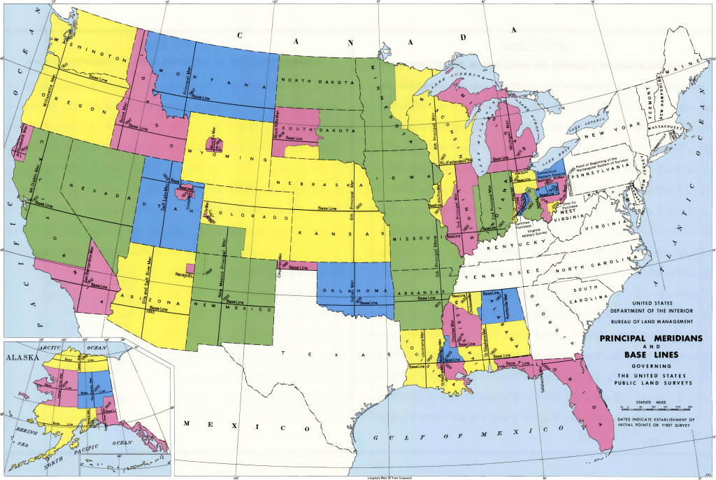
Last time we talked about the metes and bounds survey system that was used in the eastern states (colonies prior to our nation’s creation). This time let’s look at the survey system used the the rest of the United States, in the public lands states, called the “rectangular survey system.”
This survey is based on a grid system using a series of baselines and meridians across the U.S.
USGS BLM Map of Baselines and Meridians
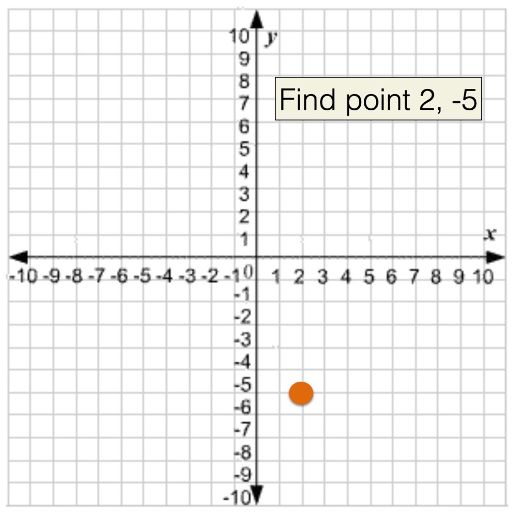
If you ever learned about how to find a point on a grid in math class you, learned that (2, -5) meant that you go right 2 points on the X axis, and down 3 points on the Y axis.
Grid system from math class.
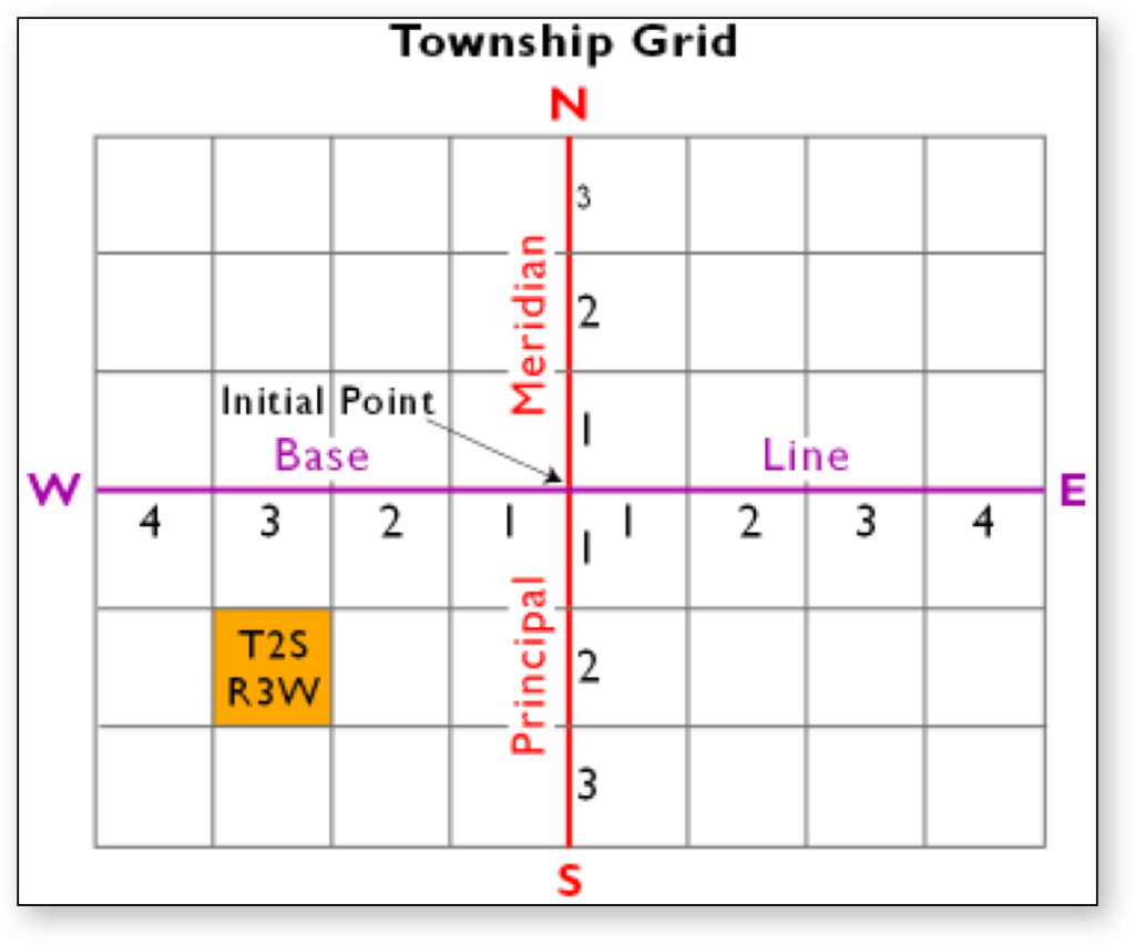
The rectangular survey works the same, except that we use the cardinal directions instead of positives and negatives, and the directions are referred to as townships and ranges such that a square from the grid is called “township 2 south, range 3 west.’ Each of these township/ranges is 36 square miles.
Example showing the location of township 2 south, range 3 west
But wait, there’s more…
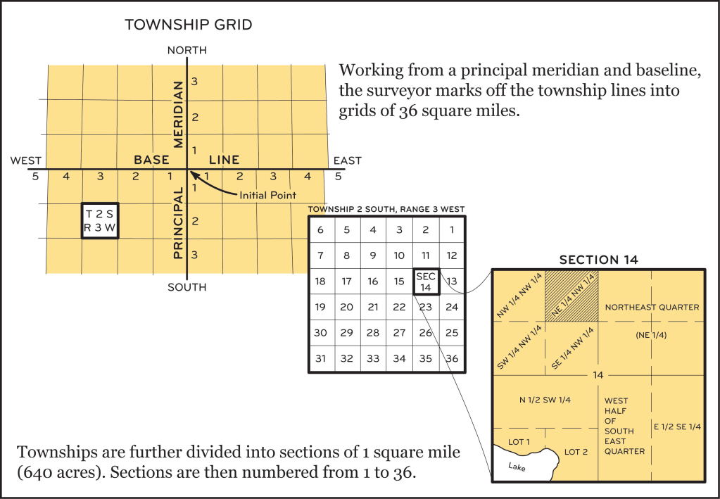
Inside each one of those township and ranges, the land is further subdivided into 36 1-square mile sections, numbered 1-36. AND THEN, each one of those 1 square mile sections is further divided into “aliquots.” Those smallest sections are divided into halves or quarters depending on how many acres someone received.
The rectangular system divisions.
So, when you find a land description for a rectangular survey system piece of land, it will read like this: N 1/2, SW 1/4, of section 14 in township 2 s, range 3 w (or north half of the southwest quarter of section 14 in township 2 south, range 3 west). The land description might also mention the principle meridian though not always. From context of where the land is located, you can often figure it out without naming the meridian (refer to the first map in this post).
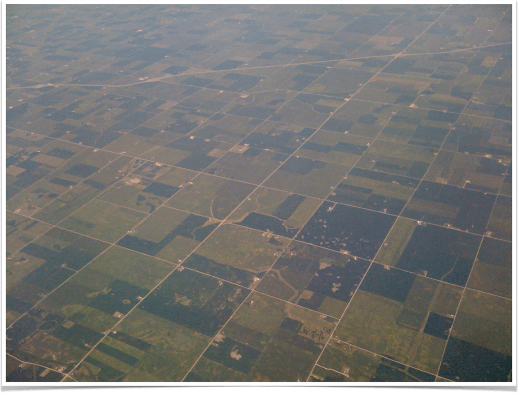
It is because of this grid system of surveying that this is the view out your airplane window when you fly over the midwest:
As described in the last post, there are two main survey methods in the United States. This post will discuss briefly the system of “metes and bounds.” There is a lot to know about this system and one blog post isn’t going to cover everything. In fact, they offer week-long institute courses on this subject (See SLIG 2023 course line-up.)
The metes and bounds system is a centuries-old system that was used in England and brought over with the early colonists. The land descriptions are in a “narrative” style that begin with a particular point and work their way around the land parcel being described. The describe physical points and markers such as trees, rocks, rivers and creeks, and often they will mention neighboring land lines. These types of descriptions heavily depend on physical characteristics of the land and because of that, the land description can change over time or be difficult to re-survey because those markers are no longer there. Trees die or blow down in storms, rocks get moved, rivers and creeks change their shape during floods, and so on.
The land description is a series of calls that give a point of reference, a direction, and a distance. The description uses “metes” and “bounds”:
metes – angles of the property, and in what direction (45 degrees southwest)
bounds – boundary lines of the property, length (60 chains, along John Smith’s line)
Metes and bounds land description, drawn by author’s spouse.
A metes and bounds description will read like “Beginning at the great white oak, 45 degrees southwest, 30 chains to the felled maple; 76 degrees southwest, 60 chains along John Smith’s line to the marked oak; 5 degrees southwest 16 chains, to the big rock…” You will get odd shaped land parcels. These unique shapes are very helpful if you are trying to reconstruct an area or neighborhood because they should fit together like a puzzle.
The cool thing about these land descriptions is that the naming of the neighbors giving you an instant “FAN Club” member (Friends, Associates, Neighbors). You also get a rough idea of what some of the land might have looked like. (I’ve seen a land descriptions out of Texas that used things like an old axle or a railroad ties as the markers, because the land was desolate and there weren’t any trees or rocks to use as starting points!)
Vocabulary you will see:
Acre – 43,560 square feet, 160 square rods
Arpent – Similar to acre, used in French sections of US (LA, MS, AL, MO, FL). One arpent is .84625 acres. In MO, it was .8507 acres, or 192.5 square feet.
Chain – 66 feet long, with 100 links; one mile is 80 chains
Degree – 1/360th of the distance around a circle; used to measure direction; 0 degrees is North or South and other directions given in terms of degrees from N or S
Link – 1/100th of a chain, 7.92 inches long; 25 links = 1 rod
Perch – same as a rod
Pole – same as a rod
Rod – 16½ feet; measured as ¼ of a chain or 25 links
Vara – Unit of measure used in sections of the US settled by Spain; varying lengths; Texas vara = 33.3333 inches or 36 varas = 100 feet (the Florida vara a little larger, the Southwest vara smaller)
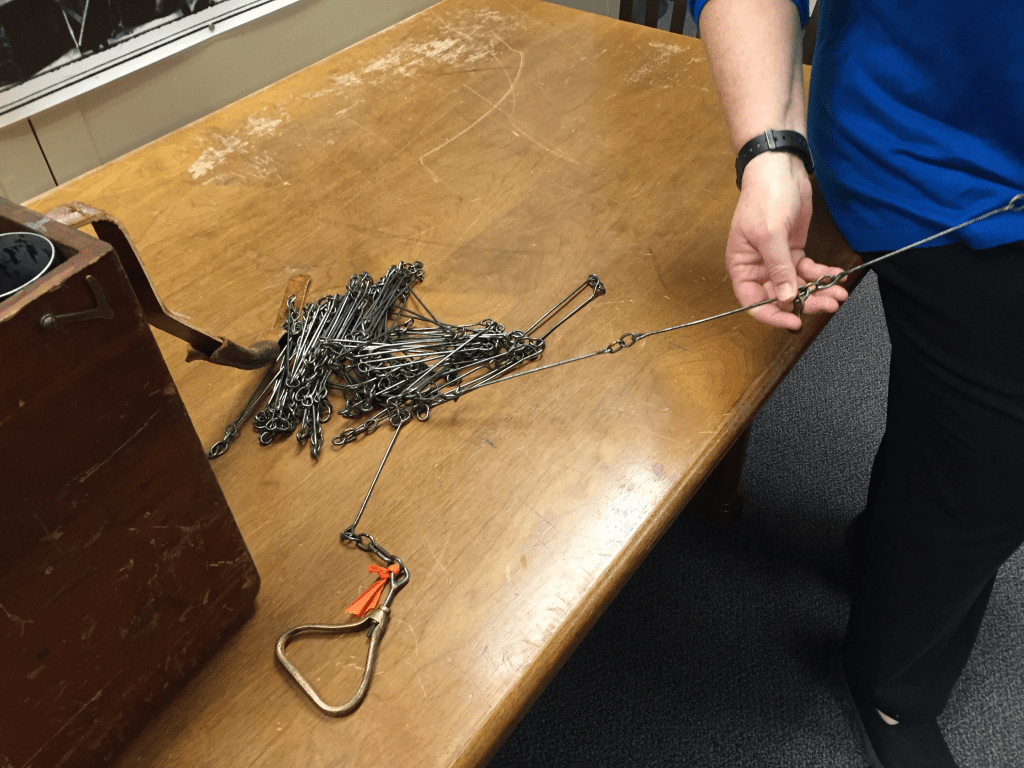
Surveyor’s chain, 100 links = 66 feet; photo taken by author.
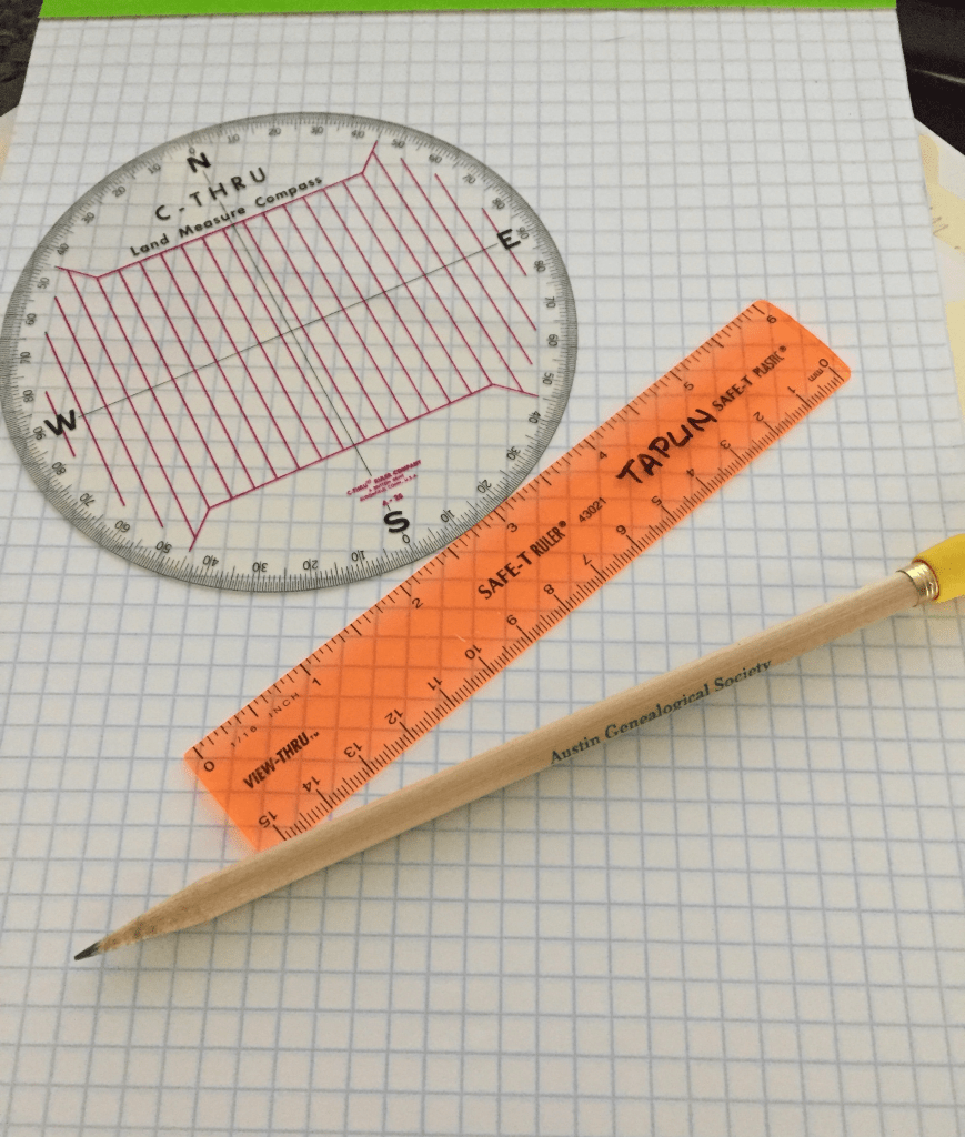
There are software packages that will draw the calls for you. I don’t do enough metes and bounds work in my research to use them. I use my trusty protractor, ruler, and graph paper to draw them when I need to.
Author’s metes and bounds drawing supplies.
There is a lot more to know about this survey system. More than I have time to cover in this blog post. If you have research in areas that used metes and bounds and want to understand your ancestors more, take a land-platting class.
We will talk about the rectangular system next time.